Navigation
OK now I want to show you how to make navigation a lot easier, more accurate and a whole lot more fun than the way you were taught.
In the early 1960s I was a charter pilot based in Kimberley, South Africa. I had a brand new licence and no idea where anywhere was. The boss would phone me and say “Davis get the aircraft out of the hangar, you are taking three people to Kakamus. They will be there in ten minutes.”
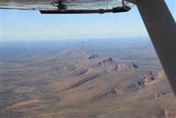
A range as significant as this one will always be shown on the chart. Use it for orientation.
It would take me more than ten minutes to find Kakamus on the map, let alone draw lines, measure angles, look for checkpoints and fill in a flight log. So I devised a cunning plan. With my protractor centred on Kimberley and the N pointer on magnetic north, I drew 10º radials out in all directions. I then drew 20 mile circles so that my map looked like a dart-board with Kimberley as the bull’s-eye.
This meant that once I had found Kakamas, or wherever, I had a ready drawn-in track-line, the magnetic heading and the distance all sorted out. In other words as soon as I knew where I was going all my flight planning was done. Each 20 mile mark would take 8 minutes at the 235 Cherokee’s cruise speed of 150mph.
Kakamas is 12.5 marks from Kimberley which means 250 miles. It’s also 12.5 x 8mins = 100mins, or 1hr 40mins. And it sits on the 290º radial.
What more do you want? You have got the line drawn, your magnetic track, the distance and the time all there right in front of you without touching pencil or paper.
Actually you’ve got much more. You have an automatic wind correction machine on your lap. If the 20 mile marks start taking 9 minutes instead of 8 – then you have a headwind. It doesn’t matter how many knots it is – you simply know that your ETA will be one minute late for each marker. 10º drift lines are also right in front of you (not that I particularly like them).
You can also guesstimate, within a minute or two, the time to any point along your route or to any diversion within 40 or 50 miles of track
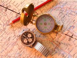
If you want to survive in the bush, clock and compass are king
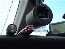
You've got to carry an awful lot of gas to compensate for this sort of goofiness
Then you have the peace of mind that comes from seeing it all laid out in front of you. There are no creeping doubts about whether you subtracted the variation instead of adding it, or whether you tied yourself up converting statute to nautics. And you won’t do anything goofy like trying to steer the TAS – which happens if you have a cockpit full of figures.
The cockpit is clean – no bits of paper and silly numbers. You just look outside and see where you are going, like God intended it.
Of course you won’t want the whole dartboard, all you need is a good bold track and the 20 mile markers. Anyhow that’s how I do it. But whichever way you navigate here are some golden rules for getting it right over featureless country.
Navigate All The Time
You can’t be lost if you knew where you were two minutes ago. If you are not sure where you were two minutes ago then you couldn’t have known your position two minutes before that. And so on. Look at it another way – the point at which you stop navigating is your last known position.
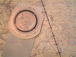
Jim tries to keep navigation uncluttered
Keep the map on your lap with a big, solid track-line pointing to the front of the aircraft. This puts everything on the map where it is on the ground. Move your finger along it as you go, and write the time on it whenever you pass a recognised feature like an airfield, river-bed, railway-line. You really can’t get lost if you do this.
Also, if you suddenly need that airfield, it can be very handy to know it’s 8 minutes behind you.
Treat your 1:1 000 000 badly - use felt-tip pens, write times on it, draw airfield diagrams on it, do your sums in the margins. Why? Because that way it gets messed up and you buy a new one. It is just silly to work with out of date maps.
Dog-leg your flight to keep within gliding distance of roads or railway lines. It makes your navigation easy - and your mind peaceful
Watch The Big Picture
When you take off don’t blindly set heading – get your neck on a swivel and absorb the big picture. Are you leaving the coast at about the proper angle? Is that major road, railway-line, power-line etc going off at the correct angle to your track? Does the range of hills look right? Is the sun where you expect it?
This must all look good within the first few minutes otherwise you will find you are steering 230 instead of 320, or setting your gyro to 300 when the compass reads 030.
Then keep the big picture going all the time. Don’t panic if you can’t tie up the exact spot where the secondary road crosses the dried-up river-bed. It doesn’t matter as long as the railway line is where you expect it, you are still tracking towards the salt-pans, and the power-line is going off at the proper angle.
Common-Sense v Nit-Picking Numbers
When a low-hour pilot gets into the cockpit with an armfull of papers, numbers, whirly-wheels, calculators, graphs and tables He is about to become a confused human being. Your chances of getting lost are in direct proportion to the volume of numbers you use.
I’m not saying don’t use numbers. Do whatever you need to give you a heading and some ETA’s - just don’t clutter the cockpit with figures. Leave the background work in the background. Only have on your lap what common-sense dictates you will need. This leaves you free to keep your eyes outside to make sure that the scenery conforms to the map.
Experienced bush-pilots and military pilots often have all they need written on the map. They use a bold track-line with 20 mile markers and an arrow showing the magnetic track. Solid, basic, common-sense stuff.
Be a Detective
Squeeze every bit of information out of each clue on the map.
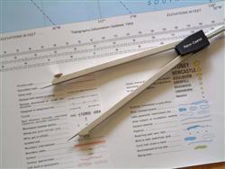
Get familiar with the chart's legend. Know what all these marks will look like on the landscape.
Tiny symbols can represent major landmarks. The minute blue dot on your map that indicates a waterhole is likely to be the centre of radiating animal tracks you can see for miles. Those little brown sandridges on the chart give a wonderful indication of direction. If your track crosses them at 25 degrees - you will see exactly that on the ground.
That miniature pick and shovel depicting a mine might be a dump you can spot 50 miles away; but it might also be a hole in the ground that you will never see. Beware the minute black circle which hints at a Place of local importance. This haven could be a post office hiding under a tree, but you may identify it as a bunch of farm buildings 20 miles away. It could equally be a bunch of huts in the bush forming the hub of many paths.
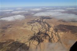
Always look at the big picture
Be careful about using roads - they change. Railway lines and rivers are less fickle. In the bush, a road might be the right one - but a railway-line going in the right direction is the railway line.
Fly high – 8 000’ to 10 000’ gets you above the heat and turbulence; it gives excellent VHF range, and you can see forever. But it also flattens hills so you won’t get much help from those spot heights and contours.
Watch out for birds even high up, and particularly near inland water. Get your pax involved in playing “spot the birdie”.
With a late afternoon ETA, err to the west of your destination. You will see it 40 miles away with the sun shining on white walls. And you can miss it by half a k if you are on the other side peering into the setting sun.
That must be Pofadder
Because something is roughly on track or close to ETA it is easy to say, “That must be Bongalong”. Don’t do it – it’s guaranteed to get you lost. Once you have five supporting features you are permitted a tentative, “That might be Bongalong”.
Don’t Trust Your Feelings
You want to get lost – follow your feelings. I once tested a student who kept edging off to the left because he has this feeling we were right of track. After half an hour he had turned round – we had gone through an unbelievable 140 degrees. Sound silly? It’s easy to do. The rule is very simple - only alter heading when you have a positive reason.
Lost? Nonsense
If you think you are lost – stick to your heading. Don’t circle or wander. Now get the big picture: the mountains are still on your left; you haven’t crossed the railway yet. You can’t have gone more than 100 miles since the river, or less than 70, and you can’t be more than 20º off track - so you must be somewhere in this area. This means you know your position within 30 miles – that’s not lost. Head for a line-feature if you want – the road, the hills, the railway or the coast. Being lost is in your head - it is not a physical condition.
GPS is not a Nav System - it’s a Back Door
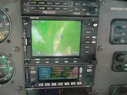
If you can't do without it, cancel the trip.
If you can’t do without it, then cancel the trip. If you see it as a back door – then you understand the game.
SAR
Always let someone know your route, even if you don’t file a flight plan. It can make the difference between getting found and dying in the bush.
The Greybeard
Finally, there’s no substitute for local knowledge. Get hold of the local greybeard, buy him a beer and ask him about the special what ifs and back doors for this flight. Then relax and have fun.
About Jim Davis:
Jim Davis has two passions - flying training and writing. He has combined these to write several books and hundreds of articles about flying. Jim has 15,000 hours flying experience, including ten thousand hours as a civil and military flying instructor. If you enjoyed these tips from Jim on staying safe in the outback, go to his website at http://jimdavis.com.au and have a look at his PPL Manual - a great resource for students and licensed pilots and a best seller on two continents.
